Local and natural history
The origins of Hatherton and Walgherton
Hatherton is listed in the Domesday book in 1086. The name is first recorded as Hatherton in 1262 and is believed to mean ‘farmstead (ton) where hawthorn grows’. The Domesday Book describes Hatherton as follows:
"Ulfketel held it; he was a free man. 1 hide paying tax. Land for 5 ploughs. In lordship 1; 2 ploughman; 2 villagers and 1 smallholder with 1 plough. Woodland 1½ league long and as wide; 1 enclosure. Value of these 2 manors before 1066, 40s; now 10s."
Walgherton is also listed in the Domesday book and is believed to derive its name from ‘farmstead or village of a man called Walhhere’. The Domesday Book describes Walgherton as follows:
"Gunning and Haldane held it as 2 manors; they were free men. 1 hide and 1 virgate paying tax. Land for 2 ploughs. 1 there, with 1 ploughman; 1 rider and 2 smallholders with 1 plough. Value before 1066, 9s; now 5s; found waste."
The current Neighbourhood Plan contains a summary of the history of the combined parishes and is a useful starting point for research.
For more information
We would like to build up a library of local historical information, and would welcome any contributions!
Here are a few snippets gleaned from various websites.
Old maps
Cheshire East have an excellent website with tithe maps which show a comparison between the present day and the records in the 19th century. These tithe maps can be accessed at this Cheshire East Archives link below.
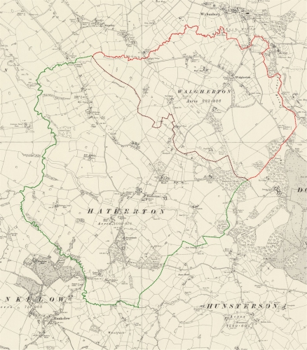
Historic map of Hatherton and Walgherton
This map is taken from the 1888-1913 OS Six Inch map of Hatherton and Walgherton. The boundaries are the parish boundaries at that time and do not accurately reflect the current boundaries. Hatherton is bounded on the west by the River Weaver, on the north by the Artle Brook and on the south by Birchall Brook. Walgherton is bounded on the north and east by Howbeck Brook, Wybunbury Brook and Forge Brook although these are all the same stream as Artle Brook. The joint boundary is more arbitrary and follows field boundaries. Interestingly, Wybunbury parish extends across the section of brook of the same name as does a part of Lea parish.
Reproduced with the permission of the National Library of Scotland. You can click on the map to see it enlarged.
Listed buildings and ancient monuments
Hatherton and Walgherton contain a number of buildings of Grade 2 listing. Hatherton has seven Grade 2 and one Grade 2* building plus the Birchall Bridge, the old bridge on the A529 over Birchall Brook. The bridge has been preserved because of the straightening of the A529 on the Hatherton/Hankelow border. Walgherton has four Grade 2 listed buildings. Details of listed buildings can be found on the Historic England website.
Natural environment
Hatherton and Walgherton contain one site of special scientific interest (SSSI). This is a section of the bank of the River Weaver in Hatherton known as Hatherton Flush. The site is listed for its assemblage of wetland plants. More details can be read on the Natural England website.
Outside our parish
Hatherton and Walgherton border on to eight other parishes.
These
are shown on the diagram to the right together with the major and minor
roads through Hatherton and Walgherton.
- Wybunbury (north)
- Lea (northeast)
- Doddington (east)
- Hunsterson (southeast)
- Hankelow (south)
- Austerson (west)
- Batherton (northwest)
- Stapeley (north)
